


Function:
- 1-D Vertical Electrical Sounding (VES), Self-Potential (SP) & Induced Polarization (IP) Sounding: Explore subsurface electrical properties and polarization at depth. Ideal for layered earth investigations.
- 1-D Resistivity & Induced Polarization (IP) Profiling: Map lateral variations in resistivity and chargeability along a line. Effective for identifying near-surface anomalies.
- 2-D Resistivity Imaging (using Centralized Imaging Cable): Create 2D cross-sections of subsurface resistivity using a centralized cable setup. Suitable for detailed geological structure mapping.
- 2-D Resistivity & Induced Polarization (IP) Imaging (using Distributed Imaging Cable): Generate 2D resistivity and IP cross-sections with a distributed electrode cable. Enhanced sensitivity for complex geological environments.
Configuration:
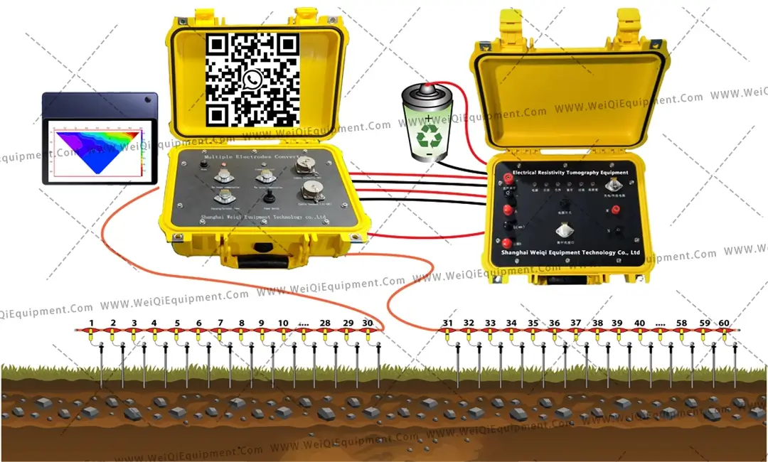
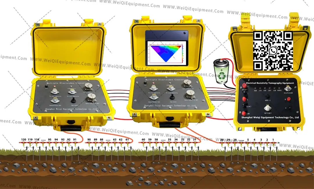

Application scope:
1- Distinguish between fresh water and salt water
2-Making a subsurface map to overview the soil types/lithology
3-Determining caves, voids and sinkholes before drilling and foundation work
4-Determining optimal locations for drilling groundwater wells
5-Investigating the depth to bedrock
6-Monitoring engineered and natural slopes with a high potential for landslides
7-Investigating and monitoring pollution plumes
8-Determining economically-important mineral deposits
9-Delineating archeological sites
10-Time lapse Monitoring of subsurface processes such as groundwater recharge, saltwater intrusion, dam leakage, and mining operations
11-University Research or Training projects
The following are the most frequently used applications
Hydrogeology & Groundwater:
Shallow & Deep Aquifer Mapping: Locate groundwater resources with geophysical surveys. #aquifermapping #groundwaterexploration
Groundwater Recharge Zone Identification: Pinpoint areas for sustainable water management. #waterrecharge #groundwatermanagement
Underground Water Inspection: Assess well integrity and water quality using geophysical methods. #waterwellinspection #groundwaterassessment
Engineering Geology:
Foundation Study & Pre-Concrete Structure Identification: Evaluate subsurface conditions for construction projects. #foundationstudy #engineeringgeology
Lithology Mapping:Determine subsurface rock types and geological formations. #lithologypapping #subsurfacesurvey
Soil Piping & Tunnel Erosion Study:Detect voids and erosion risks in soil and tunnels. #soilpiping #tunnelevaluation
Karst & Void Investigation: Locate cavities and karst features with geophysical techniques. #karstinvestigation #voiddetection
Land Subsidence & Landslide Geometry Mapping: Analyze ground deformation and landslide structures. #landsubsidence #landslidemonitoring
Environmental & Resource Assessment:
Environmental Site Assessment: Investigate soil and groundwater contamination. #environmentalassessment #siteinvestigation
Saline Intrusion Study: Delineate freshwater and saltwater boundaries. #salineintrusion #freshwatermanagement
Dam Seepage Study: Identify leakage pathways in dam structures. #damseepage #daminspection
Metal & Non-Metal Mineral Resources Detection: Explore for mineral deposits using geophysical methods. #mineralexploration #geophysicalsurvey
Infrastructure & Disaster Prevention:
City Geophysical Exploration:Subsurface mapping for urban development. #citygeophysics #urbansurvey
Railway & Bridge Inspection: Assess structural integrity using geophysical techniques. #railwayinspection #bridgeinspection
Dam Base & Flood Protection Levee Inspection: Detect faults and weaknesses in critical infrastructure. #daminspection #leveesurvey
Geothermal Prospecting: Identify potential geothermal energy resources. #geothermalenergy #geothermalexploration
Landslides & Geological Disaster Exploration: Investigate and map geological hazards. #landslideexploration #geologicalhazards

Performance parameters
3.1 WQ Digital Multifunctional DC Electricity Meter
① Receiving part
Voltage measurement range: ± 60V, 32-bit A/D
Voltage measurement accuracy: ± 0.1% ± 1 word
Maximum sampling resolution of voltage: 5nV
Input impedance: ≥ 50M Ω
Measurement accuracy of apparent polarizability: ± 0.2% ± 1 word
Current measurement range: 6A, 32-bit A/D
Current measurement accuracy: ± 0.1% ± 1 word
Maximum current sampling resolution: 10nA
50HZ power frequency interference suppression: 80dB
SP compensation range: ± 10V
Input protection voltage: 1000V
② Launch section
Maximum power supply voltage: 1500V
Maximum power supply current: 6A
Maximum output power: 9000W
Power supply pulse width: 1-60s, duty cycle 1:1
③ Other
WQ-60 reduced version widened. png
Instrument power supply: built-in 12V/6AH lithium battery (or external 12V power supply), capable of continuous operation for more than 24 hours
Host interface: A, B, M, N, DC high voltage, external battery and charging, centralized interface, etc
Volume: 339mm × 295mm × 152mm
Weight: 5.7kg
Working temperature: -10 ℃~+50 ℃, 95% RH
Storage temperature: -20 ℃~+60 ℃
3.2 Converter (WQ series)
Overall power consumption: 50 mA
Insulation performance: 500M Ω
Maximum allowable current: 2.5 A
Maximum voltage withstand: 500VDC
L Electric shock conduction resistance: less than 0.1 Ω
Total number of conversion electrodes: 60 or 120
Instrument power supply: built-in rechargeable lithium battery, capable of working for 60 hours continuously
Operation method: Connect and control with an Android system phone or tablet Bluetooth, forming a human-machine dialogue operation.
L Device modes: Winner, dipole dipole, joint profile, differential, Shibei, Wenshi 1, Wenshi 2, cross hole dipole, monopole, bipolar, triple pole, four stage, triple pole rolling, etc
3.3 Centralized high-density resistivity cable
Widening of high-density cables. png
Maximum working voltage: 500V
Maximum working current: 2.5A
Cable: 32 cores, outer diameter Φ 6mm
Tap spacing: specified by the user when ordering (usually 5m or 10m)
Cable insulation: insulation between any two core wires ≥ 500M Ω/500V
Quantity of each converter: 2 pieces/60 channels, 4 pieces+2 extension wires/120 channels (with 30 electrode taps/piece)


